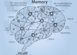
SLAM, Self-Localization and Autonomous Navigation
Tyche moves autonomously, avoid obstacle, explore the unknown space and create virtual map, estimate its own location in the virtual map simultaneously.
Hardware
1)IR sensor: to sense forward to detect object in front of tyche
2)IMU sensor:
- based on android built-in gyro sensor and tyche wheel encoder)
- to estimate robot position and orientation (2D pose) relative to the initial state.
- (good) its computation cost is very small, with good performance
- (bad) the drift error will be accumulated and it can not build space map, its blind.
3)Visual sensor:
- Extra camera module with 320×240 @30 fps image sensor, FOV should be 120 degrees
- to estimate robot pose and extract 3D features from environment simultaneously.
- (good) it create 3d point cloud from environment. The map can be created based on it.
- (bad) both computing cost and memory cost is very heavy.
Development progress
- Fuse IMU and visual data to generate 3d point clouds as sparse sub-maps.
- match and merge sub-maps / optimize the 3d point could
- Create high-level virtual map with user annotation (from verbal input or other methods)
- Application with AI
SLAM Visualization
SLAM Visualization
- Implement a 3D visualization of simultaneous localization and mapping (SLAM) based on raw sensor data provided by Tyche with Android based cellphone.
- Implements a particle filter to track the robot trajectories.
Visualize
- Sensor data
- Coordinate frames
- Maps being built
Current status: Waiting for testing with real data